
Castle Mountain topographic map
Interactive map
Click on the map to display elevation.
About this map
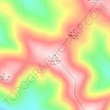
Name: Castle Mountain topographic map, elevation, terrain.
Location: Castle Mountain, Coos County, New Hampshire, United States (44.75961 -71.47930 44.75971 -71.47920)
Average elevation: 937 m
Minimum elevation: 721 m
Maximum elevation: 1,085 m
Other topographic maps
Click on a map to view its topography, its elevation and its terrain.
Colebrook
United States > New Hampshire > Coos County
Colebrook, Coös County, New Hampshire, 03576, United States
Average elevation: 476 m
Mount Pisgah
United States > New Hampshire > Coos County > Clarksville
Mount Pisgah, Clarksville, Coos County, New Hampshire, United States
Average elevation: 735 m