
Colebrook topographic map
Click on the map to display elevation.
Colebrook
According to the United States Census Bureau, the town of Colebrook has a total area of 40.7 square miles (105.5 km2), of which 40.5 square miles (104.9 km2) are land and 0.2 square miles (0.5 km2) are water, comprising 0.51% of the town. The highest point in Colebrook is Van Dyck Mountain, elevation 2,760 feet (840 m), in the northeast corner of the town. Colebrook's western view is dominated by Monadnock Mountain, elevation 3,148 ft (960 m), in Lemington, Vermont. Colebrook is drained by the Mohawk River, which flows into the Connecticut River. Beaver Brook joins the Mohawk from the north in Colebrook village. The town lies almost fully within the Connecticut River watershed, with a tiny portion of the northeast corner of town lying in the Androscoggin River watershed.
About this map
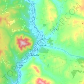
Name: Colebrook topographic map, elevation, terrain.
Location: Colebrook, Coös County, New Hampshire, 03576, United States (44.85632 -71.52306 44.94316 -71.30820)
Average elevation: 476 m
Minimum elevation: 300 m
Maximum elevation: 953 m
Other topographic maps
Click on a map to view its topography, its elevation and its terrain.