Geolocate
👉 Easily get elevation data in JSON, GeoTIFF and KML formats using Elevation API
Thank you for supporting this site ❤️
Make a donation

Shannon topographic map

Click on the map to display elevation.

About this map

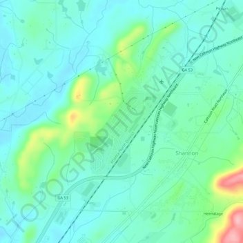
Name: Shannon topographic map, elevation, terrain.

Location: Shannon, Floyd County, Georgia, 30172, United States (34.32360 -85.11285 34.36137 -85.05906)

Average elevation: 211 m

Minimum elevation: 178 m

Maximum elevation: 327 m

Other topographic maps

Click on a map to view its topography, its elevation and its terrain.

Radio Springs

United States > Georgia > Floyd County

Average elevation: 243 m

Berryhill

United States > Georgia > Floyd County > Rome

Average elevation: 207 m

Cave Spring

United States > Georgia > Floyd County

Average elevation: 237 m

Gear up for your next adventure:

💧Hydration Pack - Hands-free hydration system for long hikes
🚑Survival Whistle - Signal for help across long distances in mountains
💧Collapsible Water Bottle - Space-saving water bottle for outdoor activities
🥾Trekking Poles - Adjustable trekking poles to reduce knee stress and improve stability
🥾Waterproof Hiking Boots - Boots keeping your feet dry in wet conditions

As an Amazon Associate, this site earns from qualifying purchases at no extra cost to you.