Geolocate

Pearl topographic map

Click on the map to display elevation.

About this map

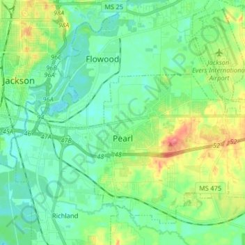
Name: Pearl topographic map, elevation, terrain.

Location: Pearl, Rankin County, Mississippi, United States (32.23559 -90.16726 32.32583 -90.03779)

Average elevation: 91 m

Minimum elevation: 72 m

Maximum elevation: 138 m

Other topographic maps

Click on a map to view its topography, its elevation and its terrain.

Lakeland

United States > Mississippi > Rankin County > Richland

Average elevation: 90 m

Value

United States > Mississippi > Rankin County > Brandon

Average elevation: 125 m

Cleary

United States > Mississippi > Rankin County

Average elevation: 103 m

Johns

United States > Mississippi > Rankin County

Average elevation: 118 m

Lakeshore

United States > Mississippi > Rankin County

Average elevation: 92 m

Sinai

United States > Mississippi > Rankin County

Average elevation: 89 m

Plainview

United States > Mississippi > Rankin County > Richland

Average elevation: 96 m

Gear up for your next adventure:

🧥Waterproof Pants - Keep dry during rainy hiking conditions
🔦LED Headtorch - Bright and durable light for night activities
🧢Hiking Hat - Sun-protective and breathable hats for long treks
🛰️Satellite Messenger - Emergency communication for areas with no cell service
🥾Approach Shoes - Shoes designed for climbing approaches and rugged trails

As an Amazon Associate, this site earns from qualifying purchases at no extra cost to you.