Geolocate

Indianola topographic map

Click on the map to display elevation.

About this map

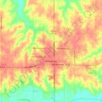
Name: Indianola topographic map, elevation, terrain.

Location: Indianola, Warren County, Iowa, 50125, United States (41.33250 -93.61124 41.40235 -93.52032)

Average elevation: 278 m

Minimum elevation: 241 m

Maximum elevation: 301 m

Other topographic maps

Click on a map to view its topography, its elevation and its terrain.

Beech

United States > Iowa > Warren County

Average elevation: 266 m

Spring Hill

United States > Iowa > Warren County > Spring Hill

Average elevation: 265 m

Cumming

United States > Iowa > Warren County > Cumming > Cumming

Average elevation: 290 m

Gear up for your next adventure:

🛶Kayak Dry Bag - Waterproof storage for kayaking adventures
🧣Merino Neck Gaiter - Protects against wind, sun, and cold at high altitudes
🧦Crew Hiking Socks - Comfortable socks for long-distance hikes
Family Camping Tent - Spacious tent suitable for family camping trips
💡Portable Camping Lamp - Rechargeable lamp for campsite lighting

As an Amazon Associate, this site earns from qualifying purchases at no extra cost to you.