
Make a donation
Gear up for your next adventure:
As an Amazon Associate, this site earns from qualifying purchases at no extra cost to you.
Neu Wulmstorf topographic map
Click on the map to display elevation.
Make a donation
Gear up for your next adventure:
As an Amazon Associate, this site earns from qualifying purchases at no extra cost to you.
Neu Wulmstorf
Further up, the villages Wulmstorf, Daerstorf, Schwiederstorf, Rade are marking the highest elevations of Neu Wulmstorf on the western outskirts of the Harburg Hills.
Make a donation
Gear up for your next adventure:
As an Amazon Associate, this site earns from qualifying purchases at no extra cost to you.
About this map
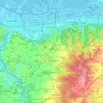
Name: Neu Wulmstorf topographic map, elevation, terrain.
Location: Neu Wulmstorf, Harburg, Lower Saxony, 21629, Germany (53.36442 9.72640 53.50530 9.86183)
Average elevation: 44 m
Minimum elevation: -2 m
Maximum elevation: 154 m
Make a donation
Gear up for your next adventure:
As an Amazon Associate, this site earns from qualifying purchases at no extra cost to you.
Other topographic maps
Click on a map to view its topography, its elevation and its terrain.