
Make a donation
Gear up for your next adventure:
As an Amazon Associate, this site earns from qualifying purchases at no extra cost to you.
Harpstedt topographic map
Click on the map to display elevation.
Make a donation
Gear up for your next adventure:
As an Amazon Associate, this site earns from qualifying purchases at no extra cost to you.
About this map
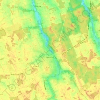
Name: Harpstedt topographic map, elevation, terrain.
Average elevation: 40 m
Minimum elevation: 21 m
Maximum elevation: 50 m
Make a donation
Gear up for your next adventure:
As an Amazon Associate, this site earns from qualifying purchases at no extra cost to you.
Other topographic maps
Click on a map to view its topography, its elevation and its terrain.
Make a donation
Gear up for your next adventure:
As an Amazon Associate, this site earns from qualifying purchases at no extra cost to you.
Make a donation
Gear up for your next adventure:
As an Amazon Associate, this site earns from qualifying purchases at no extra cost to you.
Nordenholz
Deutschland > Niedersachsen > Landkreis Oldenburg > Hude (Oldenburg)
Average elevation: 20 m
Make a donation
Gear up for your next adventure:
As an Amazon Associate, this site earns from qualifying purchases at no extra cost to you.
Vielstedt
Deutschland > Niedersachsen > Landkreis Oldenburg > Hude (Oldenburg)
Average elevation: 19 m
Make a donation
Gear up for your next adventure:
As an Amazon Associate, this site earns from qualifying purchases at no extra cost to you.
Korsorsberg
Deutschland > Niedersachsen > Landkreis Oldenburg > Wardenburg > Achternmeer > Korsorsberg
Average elevation: 10 m
Osenberge
Deutschland > Niedersachsen > Landkreis Oldenburg > Hatten
Die Osenberge sind keine Berge im eigentlich Sinne, da sie sich nur wenige Meter über das Niveau des westlichen und östlichen Umlandes erheben. Sie sind aber die höchsten Erhebungen der Region, beispielsweise liegt Oldenburg auf nur etwa 5 bis 7 m Höhe. Ihre zwei höchsten, mit jeweils 23 m Höhe gleich…
Average elevation: 14 m
Make a donation
Gear up for your next adventure:
As an Amazon Associate, this site earns from qualifying purchases at no extra cost to you.
Make a donation
Gear up for your next adventure:
As an Amazon Associate, this site earns from qualifying purchases at no extra cost to you.
Baggersee Hatten bei Dingstede
Deutschland > Niedersachsen > Landkreis Oldenburg > Dingstede
Average elevation: 29 m
Bümmersteder Fleth
Deutschland > Niedersachsen > Landkreis Oldenburg > Sandkrug
Average elevation: 8 m
Make a donation
Gear up for your next adventure:
As an Amazon Associate, this site earns from qualifying purchases at no extra cost to you.
Make a donation
Gear up for your next adventure:
As an Amazon Associate, this site earns from qualifying purchases at no extra cost to you.
Vogelbusch
Deutschland > Niedersachsen > Landkreis Oldenburg > Wardenburg > Hundsmühlen
Average elevation: 5 m
Make a donation
Gear up for your next adventure:
As an Amazon Associate, this site earns from qualifying purchases at no extra cost to you.
Fünfhausen
Deutschland > Niedersachsen > Landkreis Oldenburg > Wardenburg > Achternholt
Average elevation: 11 m
Make a donation
Gear up for your next adventure:
As an Amazon Associate, this site earns from qualifying purchases at no extra cost to you.
Make a donation
Gear up for your next adventure:
As an Amazon Associate, this site earns from qualifying purchases at no extra cost to you.
Haschenbrok
Deutschland > Niedersachsen > Landkreis Oldenburg > Großenkneten > Haschenbrok
Average elevation: 26 m
Make a donation
Gear up for your next adventure:
As an Amazon Associate, this site earns from qualifying purchases at no extra cost to you.
Saager Meere, Kleiner Sand und Heumoor
Deutschland > Niedersachsen > Landkreis Oldenburg > Großenkneten
Ahlhorner Fischteiche | Bäken der Endeler und Holzhauser Heide | Barneführer Holz und Schreensmoor | Bassumer Friedeholz | Benthullener Moor | Brammer | Döhler Wehe | Glaner Heide | Große Höhe | Harberner Heide | Hasbruch | Hatter Holz | Holler- und Wittemoor | Huntloser Moor | Lethe | Mittlere Hunte |…
Average elevation: 20 m
Make a donation
Gear up for your next adventure:
As an Amazon Associate, this site earns from qualifying purchases at no extra cost to you.