
Make a donation
Gear up for your next adventure:
As an Amazon Associate, this site earns from qualifying purchases at no extra cost to you.
Steinloge topographic map
Click on the map to display elevation.
Make a donation
Gear up for your next adventure:
As an Amazon Associate, this site earns from qualifying purchases at no extra cost to you.
About this map
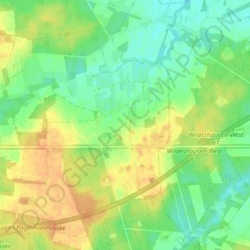
Name: Steinloge topographic map, elevation, terrain.
Average elevation: 35 m
Minimum elevation: 19 m
Maximum elevation: 52 m
Make a donation
Gear up for your next adventure:
As an Amazon Associate, this site earns from qualifying purchases at no extra cost to you.
Other topographic maps
Click on a map to view its topography, its elevation and its terrain.
Saager Meere, Kleiner Sand und Heumoor
Deutschland > Niedersachsen > Landkreis Oldenburg > Großenkneten
Ahlhorner Fischteiche | Bäken der Endeler und Holzhauser Heide | Barneführer Holz und Schreensmoor | Bassumer Friedeholz | Benthullener Moor | Brammer | Döhler Wehe | Glaner Heide | Große Höhe | Harberner Heide | Hasbruch | Hatter Holz | Holler- und Wittemoor | Huntloser Moor | Lethe | Mittlere Hunte |…
Average elevation: 20 m