Geolocate

Knapp topographic map

Click on the map to display elevation.

About this map

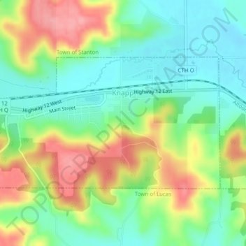
Name: Knapp topographic map, elevation, terrain.

Location: Knapp, Dunn County, Wisconsin, United States (44.94468 -92.09589 44.95915 -92.06034)

Average elevation: 311 m

Minimum elevation: 271 m

Maximum elevation: 371 m

Other topographic maps

Click on a map to view its topography, its elevation and its terrain.

Cedar Falls

United States > Wisconsin > Dunn County

Average elevation: 274 m

Mount Fuji

United States > Wisconsin > Dunn County

Average elevation: 313 m

Mount Fuji

United States > Wisconsin > Dunn County

Average elevation: 313 m

Graytown

United States > Wisconsin > Dunn County

Average elevation: 344 m

Canary Island

United States > Wisconsin > Dunn County > Menomonie

Average elevation: 262 m

Gear up for your next adventure:

🧴Bear Spray Holster - Quick-access carry for essential Canadian wilderness safety
🧥Softshell Hiking Jacket - The perfect balance of wind protection and breathability
🛰️Satellite Messenger - Emergency communication for areas with no cell service
🥾Trail Hiking Shoes - Durable shoes designed for rugged trails
🥾Lightweight Hiking Shoes - Comfortable shoes for day hikes

As an Amazon Associate, this site earns from qualifying purchases at no extra cost to you.