
Make a donation
Gear up for your next adventure:
As an Amazon Associate, this site earns from qualifying purchases at no extra cost to you.
Saalburg topographic map
Click on the map to display elevation.
Make a donation
Gear up for your next adventure:
As an Amazon Associate, this site earns from qualifying purchases at no extra cost to you.
About this map
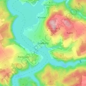
Name: Saalburg topographic map, elevation, terrain.
Average elevation: 463 m
Minimum elevation: 393 m
Maximum elevation: 570 m
Make a donation
Gear up for your next adventure:
As an Amazon Associate, this site earns from qualifying purchases at no extra cost to you.
Other topographic maps
Click on a map to view its topography, its elevation and its terrain.
Ranis
Deutschland > Thüringen > Saale-Orla-Kreis
Ranis liegt am südlichen Rand der Orlasenke zwischen dem Thüringer Holzland im Norden und dem Oberland mit dem Hohenwarte-Stausee im Süden in 380 m Höhe. Es wird durchflossen vom Schrötersbach, der südlich oberhalb der Stadt entspringt und über die Stadtwiese und danach teilweise verdolt entlang der…
Average elevation: 377 m
Wurzbach
Deutschland > Thüringen > Saale-Orla-Kreis
Die Stadt Wurzbach liegt am Nordwestrand des Frankenwaldes an der Sormitz, ist 72,31 km² groß und befindet sich in einer Höhenlage von 500 bis 725 m ü. NHN.
Average elevation: 610 m