
Make a donation
Gear up for your next adventure:
As an Amazon Associate, this site earns from qualifying purchases at no extra cost to you.
Ranis topographic map
Click on the map to display elevation.
Make a donation
Gear up for your next adventure:
As an Amazon Associate, this site earns from qualifying purchases at no extra cost to you.
Ranis
Ranis liegt am südlichen Rand der Orlasenke zwischen dem Thüringer Holzland im Norden und dem Oberland mit dem Hohenwarte-Stausee im Süden in 380 m Höhe. Es wird durchflossen vom Schrötersbach, der südlich oberhalb der Stadt entspringt und über die Stadtwiese und danach teilweise verdolt entlang der ehemaligen Stadtmauer verläuft. Er mündet später in den etwas weiter westlich verlaufenden Fischbach, der in die Kotschau fließt.
Make a donation
Gear up for your next adventure:
As an Amazon Associate, this site earns from qualifying purchases at no extra cost to you.
About this map
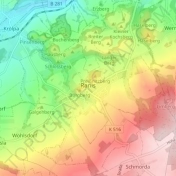
Name: Ranis topographic map, elevation, terrain.
Average elevation: 377 m
Minimum elevation: 233 m
Maximum elevation: 538 m
Make a donation
Gear up for your next adventure:
As an Amazon Associate, this site earns from qualifying purchases at no extra cost to you.
Other topographic maps
Click on a map to view its topography, its elevation and its terrain.