Geolocate

Sitio dos Marcos topographic map

Click on the map to display elevation.

About this map

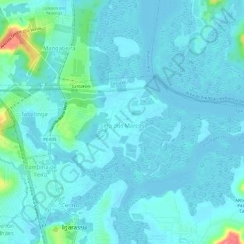
Name: Sitio dos Marcos topographic map, elevation, terrain.

Location: Sitio dos Marcos, Igarassu, Região Geográfica Imediata do Recife, Região Metropolitana do Recife, Pernambuco, Região Nordeste, Brasil (-7.82614 -34.91125 -7.80112 -34.86014)

Average elevation: 10 m

Minimum elevation: -7 m

Maximum elevation: 79 m

Other topographic maps

Click on a map to view its topography, its elevation and its terrain.

Gear up for your next adventure:

🥾Waterproof Hiking Boots - Boots keeping your feet dry in wet conditions
🪑Insulated Seat Pad - Protect your seat from cold rocks and wet logs
🛌Insulated Sleeping Pad - Critical thermal barrier between you and the cold ground
🥾Mountaineering Boots - Supportive boots for climbing and high-altitude hiking
🧭GPS Handheld Device - Reliable GPS navigation for outdoor adventures

As an Amazon Associate, this site earns from qualifying purchases at no extra cost to you.