
Make a donation
Gear up for your next adventure:
As an Amazon Associate, this site earns from qualifying purchases at no extra cost to you.
Engenho Monjope topographic map
Click on the map to display elevation.
Make a donation
Gear up for your next adventure:
As an Amazon Associate, this site earns from qualifying purchases at no extra cost to you.
About this map
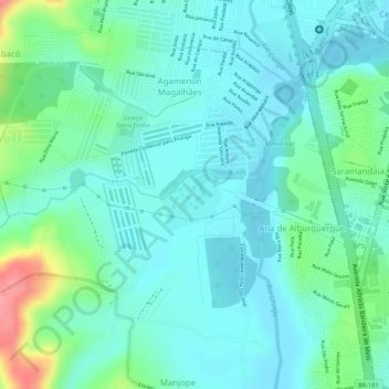
Name: Engenho Monjope topographic map, elevation, terrain.
Average elevation: 24 m
Minimum elevation: -2 m
Maximum elevation: 95 m
Make a donation
Gear up for your next adventure:
As an Amazon Associate, this site earns from qualifying purchases at no extra cost to you.
Other topographic maps
Click on a map to view its topography, its elevation and its terrain.
Agamenon Magalhães
Brasil > Pernambuco > Região Metropolitana do Recife > Igarassu
Average elevation: 27 m
Sitio dos Marcos
Brasil > Pernambuco > Região Metropolitana do Recife > Igarassu
Average elevation: 10 m
Make a donation
Gear up for your next adventure:
As an Amazon Associate, this site earns from qualifying purchases at no extra cost to you.