
Préfecture autonome tibétaine et qiang d'Aba topographic map
Interactive map
Click on the map to display elevation.
About this map
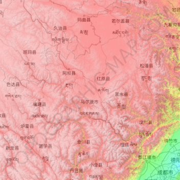
Name: Préfecture autonome tibétaine et qiang d'Aba topographic map, elevation, terrain.
Location: Préfecture autonome tibétaine et qiang d'Aba, Sichuan, Chine (30.59580 100.52558 34.31471 104.43361)
Average elevation: 3,542 m
Minimum elevation: 449 m
Maximum elevation: 6,007 m
Other topographic maps
Click on a map to view its topography, its elevation and its terrain.
Jiuzhaigou
Chine > Sichuan > གཟི་རྩ་སྡེ་དགུ་རྫོང༌། 九寨沟县
Jiuzhaigou, གཟི་རྩ་སྡེ་དགུ་རྫོང༌། 九寨沟县, 阿坝藏族羌族自治州, Sichuan, Chine
Average elevation: 2,552 m
涵水河
Chine > Sichuan > Xian de Pingchang > 涵水镇
涵水河, 涵水镇, Xian de Pingchang, Bazhong, Sichuan, Chine
Average elevation: 415 m