Geolocate

Noonan topographic map

Click on the map to display elevation.

About this map

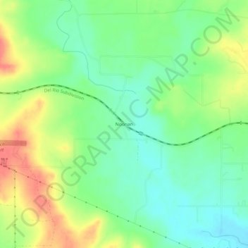
Name: Noonan topographic map, elevation, terrain.

Location: Noonan, Medina County, Texas, United States (29.24913 -98.92197 29.28913 -98.88197)

Average elevation: 247 m

Minimum elevation: 221 m

Maximum elevation: 284 m

Other topographic maps

Click on a map to view its topography, its elevation and its terrain.

Devine

United States > Texas > Medina County

Average elevation: 204 m

Castroville

United States > Texas > Medina County

Average elevation: 249 m

Castroville

United States > Texas > Medina County

Average elevation: 249 m

La Coste

United States > Texas > Medina County

Average elevation: 222 m

Gear up for your next adventure:

🦌Outdoor Trail Camera - Monitor wildlife activity near your favorite spots
🥾Hiking Leggings - Comfortable leggings for outdoor activities
🚑Survival Whistle - Signal for help across long distances in mountains
Camping Tent - Weather-resistant tents suitable for 2 to 6 people
🔦LED Flashlight - Powerful and long-lasting flashlight for camping and emergencies

As an Amazon Associate, this site earns from qualifying purchases at no extra cost to you.