Geolocate

Rio Grande topographic map

Click on the map to display elevation.

About this map

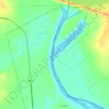
Name: Rio Grande topographic map, elevation, terrain.

Location: Rio Grande, Starr County, Texas, United States (26.54592 -99.17181 26.54765 -99.17014)

Average elevation: 71 m

Minimum elevation: 53 m

Maximum elevation: 97 m

Other topographic maps

Click on a map to view its topography, its elevation and its terrain.

Rio Grande City

United States > Texas > Starr County

Average elevation: 63 m

Falcon Heights

United States > Texas > Starr County

Average elevation: 93 m

Roma

United States > Texas > Starr County

Average elevation: 73 m

Rio Grande City

United States > Texas > Starr County

Average elevation: 63 m

Fronton Island

United States > Texas > Starr County

Average elevation: 102 m

Rio Grande City

United States > Texas > Starr County

Average elevation: 63 m

Roma

United States > Texas > Starr County

Average elevation: 73 m

Roma

United States > Texas > Starr County > Roma > Roma

Average elevation: 68 m

Gear up for your next adventure:

🧤Thermal Hiking Gloves - Grip-enhanced gloves for cold-weather altitude trekking
🎒Backpack Rain Cover - External shield to keep your entire pack dry
🥽Outdoor Goggles - Protective eyewear for outdoor activities
🥾Hiking Shorts - Breathable shorts suitable for summer hikes
🧊Insulated Water Bottle - Keeps drinks cold in summer and prevents freezing in winter

As an Amazon Associate, this site earns from qualifying purchases at no extra cost to you.