
Make a donation
Gear up for your next adventure:
As an Amazon Associate, this site earns from qualifying purchases at no extra cost to you.
Rio Grande City topographic map
Click on the map to display elevation.
Make a donation
Gear up for your next adventure:
As an Amazon Associate, this site earns from qualifying purchases at no extra cost to you.
About this map
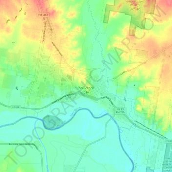
Name: Rio Grande City topographic map, elevation, terrain.
Location: Rio Grande City, Starr County, Texas, United States (26.33226 -98.86869 26.43818 -98.76983)
Average elevation: 63 m
Minimum elevation: 40 m
Maximum elevation: 102 m
Make a donation
Gear up for your next adventure:
As an Amazon Associate, this site earns from qualifying purchases at no extra cost to you.
Other topographic maps
Click on a map to view its topography, its elevation and its terrain.
Lower Rio Grande Valley National Wildlife Refuge
United States > Texas > Starr County > Rio Grande City
Average elevation: 50 m
Make a donation
Gear up for your next adventure:
As an Amazon Associate, this site earns from qualifying purchases at no extra cost to you.
Rio Grande City
United States > Texas > Starr County > Rio Grande City > Rio Grande City
Average elevation: 60 m
Garza-Gutierrez Colonia
United States > Texas > Starr County > Rio Grande City > Garza-Gutierrez Colonia
Average elevation: 59 m
Make a donation
Gear up for your next adventure:
As an Amazon Associate, this site earns from qualifying purchases at no extra cost to you.