Geolocate

Lumil topographic map

Click on the map to display elevation.

About this map

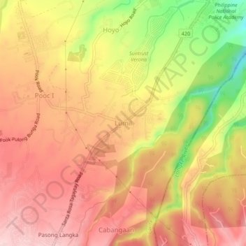
Name: Lumil topographic map, elevation, terrain.

Location: Lumil, Silang, Cavite, Calabarzon, 4118, Philippines (14.16029 120.98856 14.20029 121.02856)

Average elevation: 374 m

Minimum elevation: 224 m

Maximum elevation: 461 m

Other topographic maps

Click on a map to view its topography, its elevation and its terrain.

Carmen

Philippines > Cavite > Silang

Average elevation: 172 m

Carmen

Philippines > Cavite > Silang

Average elevation: 172 m

Gear up for your next adventure:

Backpacking Tent - Lightweight tent for long-distance hiking trips
🥾Durable Hiking Shoes - Long-lasting shoes for frequent hiking
🥽Outdoor Goggles - Protective eyewear for outdoor activities
🧰Multitool Knife - Compact and versatile tool for outdoor use
🧣Evaporative Cooling Towel - Beat the heat during intense summer climbs

As an Amazon Associate, this site earns from qualifying purchases at no extra cost to you.