Geolocate

Nerwa topographic map

Click on the map to display elevation.

About this map
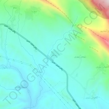
Name: Nerwa topographic map, elevation, terrain.

Location: Nerwa, Bjeel Subdistrict, Akre District, Nineveh Governorate, Iraq (36.66718 44.15162 36.70718 44.19162)

Average elevation: 586 m

Minimum elevation: 427 m

Maximum elevation: 1,176 m

Other topographic maps

Click on a map to view its topography, its elevation and its terrain.

Sinjar Mountains

Iraq > Nineveh Governorate > Sinjar District

The Sinjar Mountains (Kurdish: چیایێ شنگالێ, romanized: Çîyayê Şengalê, Arabic: جبل سنجار, romanized: Jabal Sinjār, Syriac: ܛܘܪܐ ܕܫܝܓܪ, romanized: Ṭura d'Shingar), is a 100-kilometre-long (62 mi) mountain range that runs east to west, rising above the surrounding alluvial…

Average elevation: 451 m

Mosul District

Iraq > Nineveh Governorate

Average elevation: 275 m

Mosul District

Iraq > Nineveh Governorate

Average elevation: 275 m

Badush Dam

Iraq > Nineveh Governorate > rest

Average elevation: 255 m

Atrush

Iraq > Nineveh Governorate

Average elevation: 832 m

Abas Rajab

Iraq > Nineveh Governorate

Average elevation: 230 m

Hatra

Iraq > Nineveh Governorate > Al Hadar

Average elevation: 196 m

Kabtan

Iraq > Nineveh Governorate

Average elevation: 252 m

Hanur

Iraq > Nineveh Governorate

Average elevation: 355 m

Qaim

Iraq > Nineveh Governorate

Average elevation: 293 m

Gear up for your next adventure:

🧣Merino Neck Gaiter - Protects against wind, sun, and cold at high altitudes
🎒Hiking Backpack - Lightweight and ergonomic backpacks for day hikes or multi-day treks
🧴Sunscreen SPF - Broad-spectrum sunscreen for outdoor activities
🥾Lightweight Hiking Shoes - Comfortable shoes for day hikes
🪑Ultralight Camping Stool - Compact seating for rest stops during long hikes

As an Amazon Associate, this site earns from qualifying purchases at no extra cost to you.