Geolocate

Lik topographic map

Click on the map to display elevation.

About this map

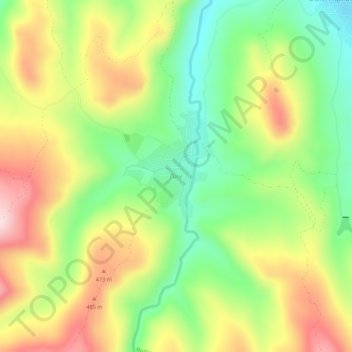
Name: Lik topographic map, elevation, terrain.

Location: Lik, Mezdra, Vratsa, Bulgaria (43.07131 23.74370 43.11131 23.78370)

Average elevation: 376 m

Minimum elevation: 221 m

Maximum elevation: 565 m

Gear up for your next adventure:

🧴Waterproofing Spray - Restore the DWR coating on jackets and tents
🧦Crew Hiking Socks - Comfortable socks for long-distance hikes
🧥Insulated Jacket - Keep warm in cold outdoor conditions
🧤Thermal Hiking Gloves - Grip-enhanced gloves for cold-weather altitude trekking
🧰Emergency Multi-Tool - Compact multi-tool for outdoor survival

As an Amazon Associate, this site earns from qualifying purchases at no extra cost to you.