Geolocate

Vilcabamba topographic map

Click on the map to display elevation.

Vilcabamba

Although the Vilcabambans did not enjoy greater longevity than the rest of the world, researchers noted that the Vilcabamban lifestyle, which included hard work in a high altitude combined with a low-calorie, low-animal-fat diet, did seem to keep the villagers healthy and vigorous in their old age.

Wikipedia (CC-BY-SA 3.0)

About this map

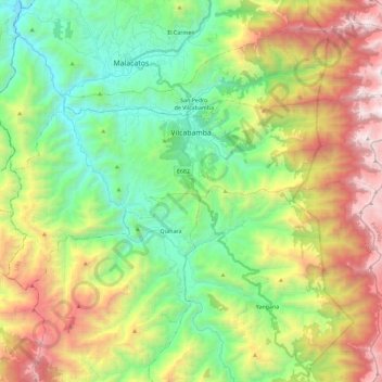
Name: Vilcabamba topographic map, elevation, terrain.

Location: Vilcabamba, Loja, Ecuador (-4.35473 -79.33383 -4.23716 -79.10511)

Average elevation: 2,202 m

Minimum elevation: 1,320 m

Maximum elevation: 3,699 m

Other topographic maps

Click on a map to view its topography, its elevation and its terrain.

Santorum

Ecuador > Loja > Loja > Vilcabamba

Average elevation: 1,606 m

Mollepamba

Ecuador > Loja > Loja > Vilcabamba

Average elevation: 1,836 m

Santiago

Ecuador > Loja > Loja > Santiago

Average elevation: 2,404 m

Numba

Ecuador > Loja > Loja > San Pedro de Vilcabamba

Average elevation: 2,277 m

Cresta de Gallo

Ecuador > Loja > Loja > Vilcabamba

Average elevation: 3,359 m

Taxiche

Ecuador > Loja > Loja > Malacatos

Average elevation: 1,611 m

Gear up for your next adventure:

Lightweight Backpacking Tent - Compact tent for efficient hiking trips
🎒Fully Waterproof Backpack - Total protection for photography gear and electronics
🧊Insulated Water Bottle - Keeps drinks cold in summer and prevents freezing in winter
🪑Insulated Seat Pad - Protect your seat from cold rocks and wet logs
🥾Hiking Boots - Sturdy boots providing ankle support and traction on rugged trails

As an Amazon Associate, this site earns from qualifying purchases at no extra cost to you.