Geolocate

Santorum topographic map

Click on the map to display elevation.

👉 Easily get elevation data in JSON, GeoTIFF and KML formats using Elevation API
Thank you for supporting this site ❤️
Make a donation

About this map

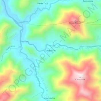
Name: Santorum topographic map, elevation, terrain.

Location: Santorum, Vilcabamba, Loja, 110119, Ecuador (-4.26952 -79.30703 -4.22952 -79.26703)

Average elevation: 1,606 m

Minimum elevation: 1,371 m

Maximum elevation: 2,058 m

Gear up for your next adventure:

🔨Vehicle Emergency Tool - Safety tool for remote road trips to trailheads
🧥Waterproof Hiking Jacket - Protect yourself from rain and wind while hiking
💧Hydration Pack - Hands-free hydration system for long hikes
🥾Trail Hiking Boots - Supportive boots for rough trails
🌬️Windproof Camp Stove - Efficient cooking even on exposed mountain peaks

As an Amazon Associate, this site earns from qualifying purchases at no extra cost to you.