Geolocate

Dravugna topographic map

Click on the map to display elevation.

About this map

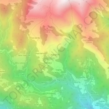
Name: Dravugna topographic map, elevation, terrain.

Location: Dravugna, Condove, Torino, Piemonte, 10055, Italia (45.12664 7.25962 45.16664 7.29962)

Average elevation: 1,218 m

Minimum elevation: 538 m

Maximum elevation: 1,944 m

Other topographic maps

Click on a map to view its topography, its elevation and its terrain.

Vasca Anti Incendio

Italia > Piemonte > Torino > Condove > Giagli

Average elevation: 582 m

Gear up for your next adventure:

🧦Hiking Liner Socks - Thin base layer to prevent friction and blisters
🛏️Camping Sleeping Mat - Comfortable mats for sleeping outdoors
🚲MTB Frame Bag - Carry tools and maps directly on your bicycle frame
🧴Insect Repellent - Protect yourself from bugs during outdoor adventures
💧Collapsible Water Bottle - Space-saving water bottle for outdoor activities

As an Amazon Associate, this site earns from qualifying purchases at no extra cost to you.