
Curitiba topographic map
Click on the map to display elevation.
Curitiba
The city covers 432.17 km2 (166.86 sq mi) on the First Plateau of Paraná. Curitiba has a topography of smooth, rounded hills, giving it a relatively regular shape. The city has an average altitude of 934.6 m (3,066 ft) above sea level. The highest point is to the north at 1,021 m (3,350 ft), and with lower altitudes at 864 m (2,835 ft) to the south.
About this map
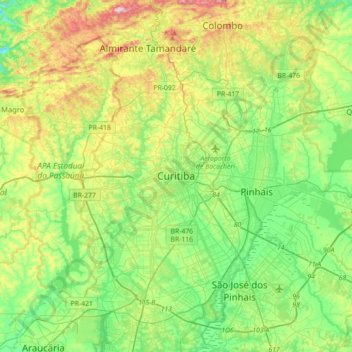
Name: Curitiba topographic map, elevation, terrain.
Average elevation: 931 m
Minimum elevation: 802 m
Maximum elevation: 1,207 m
Other topographic maps
Click on a map to view its topography, its elevation and its terrain.
Curitiba
Brazil > Paraná > Região Metropolitana de Curitiba
The city covers 432.17 km2 (166.86 sq mi) on the First Plateau of Paraná. Curitiba has a topography of smooth, rounded hills, giving it a relatively regular shape. The city has an average altitude of 934.6 m (3,066 ft) above sea level. The highest point is to the north at 1,021 m (3,350 ft), and with lower…
Average elevation: 912 m
Bosque Gutierrez
Brazil > Paraná > Região Metropolitana de Curitiba > Curitiba
Average elevation: 940 m
Colombo
Brazil > Paraná > Região Metropolitana de Curitiba
It was founded on 5 February 1890. It is located at 25º17'30" S, 49º13'27" W, at an elevation of about 1000 metres above sea level, some 18 km from state capital Curitiba. The city is the largest Italian colony in the state.
Average elevation: 972 m
Southern carcara
Brazil > Paraná > Região Metropolitana de Curitiba > Curitiba
Average elevation: 879 m
São José dos Pinhais
Brazil > Paraná > Região Metropolitana de Curitiba > São José dos Pinhais
Average elevation: 913 m