Geolocate

Yanert Fork topographic map

Click on the map to display elevation.

About this map

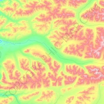
Name: Yanert Fork topographic map, elevation, terrain.

Location: Yanert Fork, Denali, Alaska, United States (63.58119 -148.77892 63.68710 -147.75349)

Average elevation: 1,171 m

Minimum elevation: 505 m

Maximum elevation: 2,348 m

Other topographic maps

Click on a map to view its topography, its elevation and its terrain.

Anderson

United States > Alaska > Denali > Anderson

Average elevation: 156 m

Kantishna

United States > Alaska > Denali

Average elevation: 678 m

Yanert Glacier

United States > Alaska > Denali

Average elevation: 1,703 m

Igloo Mountain

United States > Alaska > Denali

Average elevation: 1,085 m

Gear up for your next adventure:

🧴Insect Repellent - Protect yourself from bugs during outdoor adventures
🚑Survival Whistle - Signal for help across long distances in mountains
🧭GPS Outdoor Watch - Smart watch for navigation and fitness tracking in nature
💧Filtered Water Bottle - Safe drinking water on the go
🛶Kayak Dry Bag - Waterproof storage for kayaking adventures

As an Amazon Associate, this site earns from qualifying purchases at no extra cost to you.