
Make a donation
Gear up for your next adventure:
As an Amazon Associate, this site earns from qualifying purchases at no extra cost to you.
Ashton-under-Lyne topographic map
Click on the map to display elevation.
Make a donation
Gear up for your next adventure:
As an Amazon Associate, this site earns from qualifying purchases at no extra cost to you.
Ashton-under-Lyne
At 53°29′38″N 2°6′11″W / 53.49389°N 2.10306°W / 53.49389; -2.10306 (53.4941°, −2.1032°), and 160 miles (257 km) north-northwest of London, Ashton-under-Lyne stands on the north bank of the River Tame, about 35 feet (11 m) above the river. Described in Samuel Lewis's A Topographical Dictionary of England (1848) as situated "on a gentle declivity", Ashton-under-Lyne lies on undulating ground by the Pennines, reaching a maximum elevation of about 1,000 feet (305 m) above sea level. Generally the bedrock of the west of the town consists of coal measures, which were exploited by the coal mining industry, while the east is mainly millstone grit. Overlying the bedrock are deposits of glacial sand and gravel, clay, and some alluvial deposits. Ashton Moss, a peat bog, lies to the west of the town and was originally much larger.
Make a donation
Gear up for your next adventure:
As an Amazon Associate, this site earns from qualifying purchases at no extra cost to you.
About this map
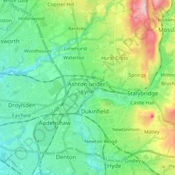
Name: Ashton-under-Lyne topographic map, elevation, terrain.
Average elevation: 129 m
Minimum elevation: 63 m
Maximum elevation: 306 m
Make a donation
Gear up for your next adventure:
As an Amazon Associate, this site earns from qualifying purchases at no extra cost to you.
Other topographic maps
Click on a map to view its topography, its elevation and its terrain.
Make a donation
Gear up for your next adventure:
As an Amazon Associate, this site earns from qualifying purchases at no extra cost to you.