Geolocate

Flippen topographic map

Click on the map to display elevation.

About this map

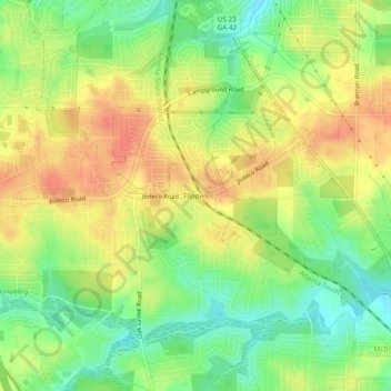
Name: Flippen topographic map, elevation, terrain.

Location: Flippen, Henry County, Georgia, 30253, United States (33.46317 -84.20742 33.50317 -84.16742)

Average elevation: 252 m

Minimum elevation: 225 m

Maximum elevation: 276 m

Other topographic maps

Click on a map to view its topography, its elevation and its terrain.

Blacksville

United States > Georgia > Henry County

Average elevation: 263 m

Locust Grove

United States > Georgia > Henry County

Average elevation: 230 m

Weems Lake

United States > Georgia > Henry County

Average elevation: 245 m

Hiram Cook Lake

United States > Georgia > Henry County

Average elevation: 248 m

Gear up for your next adventure:

🥾Mountain Hiking Shoes - Shoes with superior grip for mountainous terrain
💡LED Camping Lantern - Illuminate your campsite with long-lasting lanterns
🥾Trekking Poles - Adjustable trekking poles to reduce knee stress and improve stability
🧊Portable Cooler - Keep food and drinks cold during outdoor adventures
🧴Waterproofing Spray - Restore the DWR coating on jackets and tents

As an Amazon Associate, this site earns from qualifying purchases at no extra cost to you.