Geolocate

Film topographic map

Click on the map to display elevation.

About this map

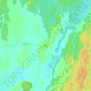
Name: Film topographic map, elevation, terrain.

Location: Film, Östhammars kommun, Uppsala County, 748 31, Sweden (60.20969 17.87453 60.24969 17.91453)

Average elevation: 30 m

Minimum elevation: 20 m

Maximum elevation: 52 m

Other topographic maps

Click on a map to view its topography, its elevation and its terrain.

Hanelundssjön

Sweden > Uppsala County > Risbergsbo

Average elevation: 68 m

Älvkarleby kommun

Sweden > Uppsala County

Average elevation: 20 m

Östhammars kommun

Sweden > Uppsala County

Average elevation: 10 m

Knivsta kommun

Sweden > Uppsala County

Average elevation: 25 m

Uppsala kommun

Sweden > Uppsala County

Average elevation: 36 m

Hargshamn

Sweden > Uppsala County

Average elevation: 5 m

Enköpings kommun

Sweden > Uppsala County

Average elevation: 24 m

Heby kommun

Sweden > Uppsala County

Average elevation: 61 m

Gear up for your next adventure:

Lightweight Backpacking Tent - Compact tent for efficient hiking trips
🥾Lightweight Hiking Boots - Boots for comfort and mobility on long hikes
🥾Mountaineering Boots - Supportive boots for climbing and high-altitude hiking
🧢Outdoor Visor - Breathable visor for sunny hikes
🪑Ultralight Camping Stool - Compact seating for rest stops during long hikes

As an Amazon Associate, this site earns from qualifying purchases at no extra cost to you.