
Make a donation
Gear up for your next adventure:
As an Amazon Associate, this site earns from qualifying purchases at no extra cost to you.
Municipio Sotillo topographic map
Click on the map to display elevation.
Make a donation
Gear up for your next adventure:
As an Amazon Associate, this site earns from qualifying purchases at no extra cost to you.
About this map
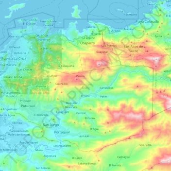
Name: Municipio Sotillo topographic map, elevation, terrain.
Location: Municipio Sotillo, Estado Anzoátegui, 6023, Venezuela (10.07915 -64.67290 10.25464 -64.44331)
Average elevation: 282 m
Minimum elevation: -1 m
Maximum elevation: 1,083 m
Make a donation
Gear up for your next adventure:
As an Amazon Associate, this site earns from qualifying purchases at no extra cost to you.
Other topographic maps
Click on a map to view its topography, its elevation and its terrain.
Make a donation
Gear up for your next adventure:
As an Amazon Associate, this site earns from qualifying purchases at no extra cost to you.
Make a donation
Gear up for your next adventure:
As an Amazon Associate, this site earns from qualifying purchases at no extra cost to you.
Puerto Píritu
Venezuela > Estado Anzoátegui > Puerto Píritu
La altitud de la ciudad es de 8 msnm.
Average elevation: 51 m
Cerro La Cueva del Tigre
Venezuela > Estado Anzoátegui > Municipio Freites > Mundo Nuevo
Average elevation: 965 m
Río Neverí
Venezuela > Estado Anzoátegui > Municipio Simón Bolívar > Barcelona
Average elevation: 35 m
Make a donation
Gear up for your next adventure:
As an Amazon Associate, this site earns from qualifying purchases at no extra cost to you.
El Tigre
Venezuela > Estado Anzoátegui > Municipio Simón Rodríguez > El Tigre
El Tigre es una ciudad de Venezuela ubicada en el estado Anzoátegui. Es la capital del municipio Simón Rodríguez y está situada al Sur del estado Anzoátegui, equidistante al río Orinoco y al mar Caribe, en la mesa de Guanipa, cruzada por el río Tigre, a una altitud de 265 m; con una temperatura media de…
Average elevation: 272 m
Make a donation
Gear up for your next adventure:
As an Amazon Associate, this site earns from qualifying purchases at no extra cost to you.
Plaza Pedro María Freites
Venezuela > Estado Anzoátegui > Municipio Freites > Cantaura
Average elevation: 241 m
Cerro Venezuela
Venezuela > Estado Anzoátegui > Municipio Simón Bolívar > Barcelona
Average elevation: 10 m
Make a donation
Gear up for your next adventure:
As an Amazon Associate, this site earns from qualifying purchases at no extra cost to you.
Playa Maurica
Venezuela > Estado Anzoátegui > Municipio Simón Bolívar > Barcelona
Average elevation: 2 m
Make a donation
Gear up for your next adventure:
As an Amazon Associate, this site earns from qualifying purchases at no extra cost to you.
Mirador de la patria
Venezuela > Estado Anzoátegui > Municipio Urbaneja > Lechería
Average elevation: 6 m
Make a donation
Gear up for your next adventure:
As an Amazon Associate, this site earns from qualifying purchases at no extra cost to you.
Cerro Venezuela
Venezuela > Estado Anzoátegui > Municipio Simón Bolívar > Barcelona
Average elevation: 10 m
Make a donation
Gear up for your next adventure:
As an Amazon Associate, this site earns from qualifying purchases at no extra cost to you.
Cerro Venezuela
Venezuela > Estado Anzoátegui > Municipio Simón Bolívar > Barcelona
Average elevation: 10 m