
Make a donation
Gear up for your next adventure:
As an Amazon Associate, this site earns from qualifying purchases at no extra cost to you.
Cerro Venezuela topographic map
Click on the map to display elevation.
Make a donation
Gear up for your next adventure:
As an Amazon Associate, this site earns from qualifying purchases at no extra cost to you.
About this map
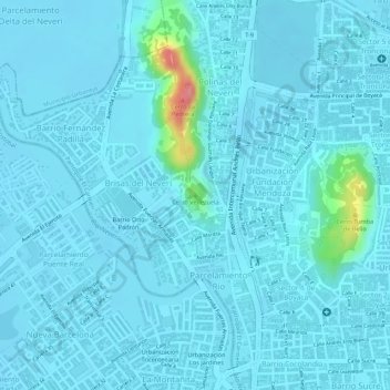
Name: Cerro Venezuela topographic map, elevation, terrain.
Average elevation: 10 m
Minimum elevation: 1 m
Maximum elevation: 102 m
Make a donation
Gear up for your next adventure:
As an Amazon Associate, this site earns from qualifying purchases at no extra cost to you.
Other topographic maps
Click on a map to view its topography, its elevation and its terrain.
La Orquídea
Venezuela > Estado Anzoátegui > Municipio Simón Bolívar > Barcelona
Average elevation: 13 m
Casco Central
Venezuela > Estado Anzoátegui > Municipio Simón Bolívar > Barcelona
Average elevation: 7 m
Río Neverí
Venezuela > Estado Anzoátegui > Municipio Simón Bolívar > Barcelona
Average elevation: 35 m
Make a donation
Gear up for your next adventure:
As an Amazon Associate, this site earns from qualifying purchases at no extra cost to you.
Parcelamiento La Encantada
Venezuela > Estado Anzoátegui > Municipio Simón Bolívar > Barcelona
Average elevation: 4 m
Nueva Barcelona
Venezuela > Estado Anzoátegui > Municipio Simón Bolívar > Barcelona
Average elevation: 6 m
Barrio José Félix Ribas
Venezuela > Estado Anzoátegui > Municipio Simón Bolívar > Barcelona
Average elevation: 7 m
Make a donation
Gear up for your next adventure:
As an Amazon Associate, this site earns from qualifying purchases at no extra cost to you.
Playa Maurica
Venezuela > Estado Anzoátegui > Municipio Simón Bolívar > Barcelona
Average elevation: 2 m
Parcelamiento Sabana Redonda
Venezuela > Estado Anzoátegui > Municipio Simón Bolívar > Barcelona
Average elevation: 5 m
Caicara de Barcelona
Venezuela > Estado Anzoátegui > Municipio Simón Bolívar > Barcelona
Average elevation: 4 m
Make a donation
Gear up for your next adventure:
As an Amazon Associate, this site earns from qualifying purchases at no extra cost to you.