
Make a donation
Gear up for your next adventure:
As an Amazon Associate, this site earns from qualifying purchases at no extra cost to you.
Daimiel topographic map
Click on the map to display elevation.
Make a donation
Gear up for your next adventure:
As an Amazon Associate, this site earns from qualifying purchases at no extra cost to you.
Daimiel
Die Stadt Daimiel liegt am Flüsschen Azuer in der weitgehend ebenen und wasserarmen Landschaft von La Mancha gut 33 km (Fahrtstrecke) nordöstlich der Provinzhauptstadt Ciudad Real bzw. ca. 170 km südlich von Madrid in einer Höhe von ca. 625 m. Das Klima ist gemäßigt bis heiß; der eher spärliche Regen (ca. 405 mm/Jahr) fällt – mit Ausnahme der zumeist eher trockenen Sommermonate – verteilt übers Jahr.
Make a donation
Gear up for your next adventure:
As an Amazon Associate, this site earns from qualifying purchases at no extra cost to you.
About this map
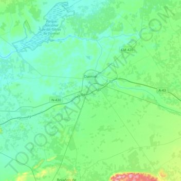
Name: Daimiel topographic map, elevation, terrain.
Location: Daimiel, Ciudad Real, Kastilien-La Mancha, 13250, Spanien (38.92339 -3.80610 39.17636 -3.44084)
Average elevation: 633 m
Minimum elevation: 601 m
Maximum elevation: 785 m
Make a donation
Gear up for your next adventure:
As an Amazon Associate, this site earns from qualifying purchases at no extra cost to you.
Other topographic maps
Click on a map to view its topography, its elevation and its terrain.
Make a donation
Gear up for your next adventure:
As an Amazon Associate, this site earns from qualifying purchases at no extra cost to you.
Make a donation
Gear up for your next adventure:
As an Amazon Associate, this site earns from qualifying purchases at no extra cost to you.