Geolocate

Streefkerk topographic map

Click on the map to display elevation.

About this map

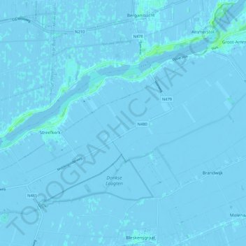
Name: Streefkerk topographic map, elevation, terrain.

Location: Streefkerk, Molenlanden, South Holland, Netherlands (51.88082 4.72397 51.92455 4.83017)

Average elevation: -1 m

Minimum elevation: -4 m

Maximum elevation: 7 m

Other topographic maps

Click on a map to view its topography, its elevation and its terrain.

Botlek

Netherlands > South Holland

Average elevation: 3 m

Meije

Netherlands > South Holland > Nieuwkoop

Average elevation: -2 m

Langeraar

Netherlands > South Holland

Average elevation: -3 m

Weerestein

Netherlands > South Holland > Hillegom

Average elevation: 0 m

Broekhuizen

Netherlands > South Holland > Gouda

Average elevation: -1 m

Ankerpark

Netherlands > South Holland > Leiden

Average elevation: 3 m

Middelsluis

Netherlands > South Holland > Numansdorp

Average elevation: 0 m

Weerestein

Netherlands > South Holland > Hillegom

Average elevation: 0 m

Meijendel

Netherlands > South Holland > Wassenaar

Average elevation: 6 m

Coepelduynen

Netherlands > South Holland > Katwijk

Average elevation: 4 m

Het Park

Netherlands > South Holland > Rotterdam

Average elevation: 4 m

Waalhaven

Netherlands > South Holland > Rotterdam

Average elevation: 3 m

Gear up for your next adventure:

🥾Hiking Boots - Sturdy boots providing ankle support and traction on rugged trails
🥾Trekking Boots - Durable boots for long-distance trekking
🥾Hiking Gaiters - Protect legs and shoes from mud, snow, and debris
🪑Insulated Seat Pad - Protect your seat from cold rocks and wet logs
Family Camping Tent - Spacious tent suitable for family camping trips

As an Amazon Associate, this site earns from qualifying purchases at no extra cost to you.