Geolocate

Whimple topographic map

Click on the map to display elevation.

About this map

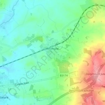
Name: Whimple topographic map, elevation, terrain.

Location: Whimple, East Devon, Devon, England, United Kingdom (50.74358 -3.38237 50.78585 -3.32595)

Average elevation: 67 m

Minimum elevation: 25 m

Maximum elevation: 169 m

Other topographic maps

Click on a map to view its topography, its elevation and its terrain.

Burrow

United Kingdom > England > Devon > East Devon > Broadclyst > Burrow

Average elevation: 30 m

Gear up for your next adventure:

🔦LED Headtorch - Bright and durable light for night activities
🧦Hiking Liner Socks - Thin base layer to prevent friction and blisters
🥾Hiking Boots - Sturdy boots providing ankle support and traction on rugged trails
🥾Hiking Shoes - Durable and comfortable shoes for trail hiking
🧥Waterproof Hiking Jacket - Protect yourself from rain and wind while hiking

As an Amazon Associate, this site earns from qualifying purchases at no extra cost to you.