
Make a donation
Gear up for your next adventure:
As an Amazon Associate, this site earns from qualifying purchases at no extra cost to you.
Ain Al Faydah topographic map
Click on the map to display elevation.
Make a donation
Gear up for your next adventure:
As an Amazon Associate, this site earns from qualifying purchases at no extra cost to you.
About this map
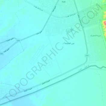
Name: Ain Al Faydah topographic map, elevation, terrain.
Location: Ain Al Faydah, Al Ain, Abu Dhabi Emirate, United Arab Emirates (24.03436 55.62897 24.10403 55.72827)
Average elevation: 237 m
Minimum elevation: 215 m
Maximum elevation: 477 m
Make a donation
Gear up for your next adventure:
As an Amazon Associate, this site earns from qualifying purchases at no extra cost to you.
Other topographic maps
Click on a map to view its topography, its elevation and its terrain.
Al Ain
United Arab Emirates > Abu Dhabi Emirate > Al Ain
Al Ain is located approximately 160 kilometres (99 mi) east of the capital Abu Dhabi, and about 120 kilometres (75 mi) south of Dubai. The eastern region covers an area of approximately 13,100 km2 (5,100 sq mi). Oman lies to the east, Dubai and Sharjah to the north, Abu Dhabi to the west and the Empty Quarter…
Average elevation: 294 m
Al Ain
United Arab Emirates > Abu Dhabi Emirate > Al Ain > Al Mutaredh
The city is located approximately 160 kilometres (99 mi) east of the capital Abu Dhabi, and about 120 kilometres (75 mi) south of Dubai. The eastern region covers an area of approximately 13,100 km2 (5,100 sq mi). Oman lies to the east, Dubai and Sharjah to the north, Abu Dhabi to the west and the Empty…
Average elevation: 294 m
Shi'bat Al Wutah
United Arab Emirates > Abu Dhabi Emirate > Al Ain > Shi'bat Al Wutah
Average elevation: 255 m
Jebel Hafeet
United Arab Emirates > Abu Dhabi Emirate > Al Ain > Jabal Hafeet
Average elevation: 777 m
Make a donation
Gear up for your next adventure:
As an Amazon Associate, this site earns from qualifying purchases at no extra cost to you.
Jabal Hafeet
United Arab Emirates > Abu Dhabi Emirate > Al Ain > Jabal Hafeet
Average elevation: 610 m
Make a donation
Gear up for your next adventure:
As an Amazon Associate, this site earns from qualifying purchases at no extra cost to you.
Green Mubazzarah Park
United Arab Emirates > Abu Dhabi Emirate > Al Ain > Mbazzarah Al Khadra
Average elevation: 305 m
Make a donation
Gear up for your next adventure:
As an Amazon Associate, this site earns from qualifying purchases at no extra cost to you.
Jabal Hafeet
United Arab Emirates > Abu Dhabi Emirate > Al Ain > Jabal Hafeet
Average elevation: 610 m
Make a donation
Gear up for your next adventure:
As an Amazon Associate, this site earns from qualifying purchases at no extra cost to you.
Sanaiya Industrial
United Arab Emirates > Abu Dhabi Emirate > Al Ain > Industrial Area
Average elevation: 290 m
Al Ain
United Arab Emirates > Abu Dhabi Emirate > Al Ain
The city is located approximately 160 kilometres (99 mi) east of the capital Abu Dhabi, and about 120 kilometres (75 mi) south of Dubai. The eastern region covers an area of approximately 13,100 km2 (5,100 sq mi). Oman lies to the east, Dubai and Sharjah to the north, Abu Dhabi to the west and the Empty…
Average elevation: 294 m
Make a donation
Gear up for your next adventure:
As an Amazon Associate, this site earns from qualifying purchases at no extra cost to you.
Sha'biyyat Al Hiyar
United Arab Emirates > Abu Dhabi Emirate > Al Ain > Al Hiyar
Average elevation: 303 m
Sha'biyyat As Silēmāt
United Arab Emirates > Abu Dhabi Emirate > Al Ain > Al Salamat
Average elevation: 233 m
Sha'biyyat Ash Shiweb
United Arab Emirates > Abu Dhabi Emirate > Al Ain > Al Shiwayb
Average elevation: 278 m
Make a donation
Gear up for your next adventure:
As an Amazon Associate, this site earns from qualifying purchases at no extra cost to you.
Make a donation
Gear up for your next adventure:
As an Amazon Associate, this site earns from qualifying purchases at no extra cost to you.