Geolocate

Cesarò topographic map

Click on the map to display elevation.

About this map

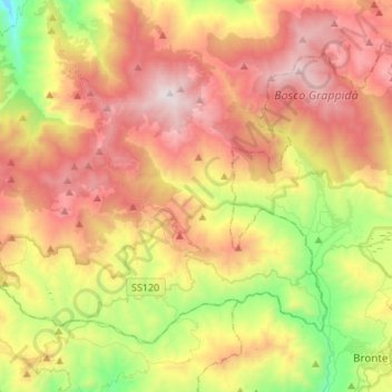
Name: Cesarò topographic map, elevation, terrain.

Location: Cesarò, Messina, Sicily, 98033, Italy (37.79504 14.53253 37.95590 14.80350)

Average elevation: 1,048 m

Minimum elevation: 294 m

Maximum elevation: 1,842 m

Other topographic maps

Click on a map to view its topography, its elevation and its terrain.

Monte Serro

Italy > Sicily > Messina > Messina

Average elevation: 92 m

Sperone

Italy > Sicily > Messina > Messina

Average elevation: 56 m

Castel di Tusa

Italy > Sicily > Messina

Average elevation: 96 m

Messina

Italy > Sicily > Messina > Messina

Average elevation: 180 m

Gear up for your next adventure:

🎒Hiking Daypack - Lightweight and durable backpacks for day trips and excursions
🛶Kayak Accessories - Essential gear for safe and fun kayaking adventures
🔦UV Flashlight - Detect minerals or specific insects in the dark
🧦Crew Hiking Socks - Comfortable socks for long-distance hikes
🥾Waterproof Hiking Shoes - Durable shoes for wet and rugged trails

As an Amazon Associate, this site earns from qualifying purchases at no extra cost to you.