Geolocate

Fernwood topographic map

Click on the map to display elevation.

About this map

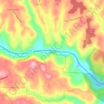
Name: Fernwood topographic map, elevation, terrain.

Location: Fernwood, Jefferson County, Ohio, 43953, United States (40.31424 -80.72758 40.35424 -80.68758)

Average elevation: 313 m

Minimum elevation: 222 m

Maximum elevation: 380 m

Other topographic maps

Click on a map to view its topography, its elevation and its terrain.

Steubenville

United States > Ohio > Jefferson County

Average elevation: 296 m

Bergholz

United States > Ohio > Jefferson County

Average elevation: 308 m

Brilliant

United States > Ohio > Jefferson County > Brilliant

Average elevation: 261 m

Steubenville

United States > Ohio > Jefferson County

Average elevation: 294 m

Toronto

United States > Ohio > Jefferson County

Average elevation: 277 m

Gear up for your next adventure:

👟Leg Gaiters - Keep debris, mud, and snow out of your boots
🧢Hiking Sun Hat - Wide-brimmed protection for exposed mountain ridges
🧴Bear Spray Holster - Quick-access carry for essential Canadian wilderness safety
🧥Softshell Hiking Jacket - The perfect balance of wind protection and breathability
🥾Hiking Shoes - Durable and comfortable shoes for trail hiking

As an Amazon Associate, this site earns from qualifying purchases at no extra cost to you.