Geolocate

Toronto topographic map

Click on the map to display elevation.

About this map

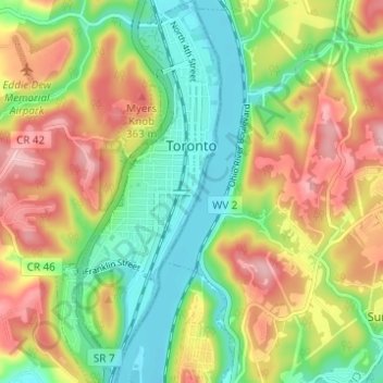
Name: Toronto topographic map, elevation, terrain.

Location: Toronto, Jefferson County, Ohio, United States (40.43647 -80.62282 40.48325 -80.59620)

Average elevation: 277 m

Minimum elevation: 198 m

Maximum elevation: 379 m

Gear up for your next adventure:

🥾Hiking Boots - Sturdy boots providing ankle support and traction on rugged trails
🛏️Camping Sleeping Mat - Comfortable mats for sleeping outdoors
🪑Insulated Seat Pad - Protect your seat from cold rocks and wet logs
Family Camping Tent - Spacious tent suitable for family camping trips
💡LED Headlamp - Hands-free illumination for night hiking and camping

As an Amazon Associate, this site earns from qualifying purchases at no extra cost to you.