Geolocate

Kataula topographic map

Click on the map to display elevation.

About this map

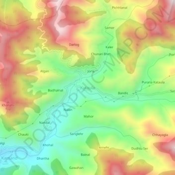
Name: Kataula topographic map, elevation, terrain.

Location: Kataula, Mandi, Himachal Pradesh, 175075, India (31.77778 76.99840 31.81778 77.03840)

Average elevation: 1,374 m

Minimum elevation: 1,027 m

Maximum elevation: 1,783 m

Other topographic maps

Click on a map to view its topography, its elevation and its terrain.

Beas River

India > Himachal Pradesh > Mandi > Pandoh

Average elevation: 962 m

Gear up for your next adventure:

🥾Mountain Hiking Boots - High-traction boots for rocky terrain
🥫Freeze-Dried Meals - Lightweight, high-calorie nutrition for multi-day treks
🦌Outdoor Trail Camera - Monitor wildlife activity near your favorite spots
🦟Insect Repellent - Keep mosquitoes and black flies away in wooded areas
🧥Ultralight Puffy Jacket - Maximum warmth that packs down to the size of an orange

As an Amazon Associate, this site earns from qualifying purchases at no extra cost to you.