Geolocate

Maharlika topographic map

Click on the map to display elevation.

About this map

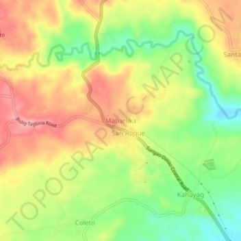
Name: Maharlika topographic map, elevation, terrain.

Location: Maharlika, Surigao del Sur, Caraga, Philippines (8.22530 126.26028 8.26530 126.30028)

Average elevation: 71 m

Minimum elevation: 5 m

Maximum elevation: 132 m

Other topographic maps

Click on a map to view its topography, its elevation and its terrain.

Bayabas

Philippines > Surigao del Sur

Average elevation: 35 m

Hinatuan

Philippines > Surigao del Sur

Average elevation: 30 m

Lingig

Philippines > Surigao del Sur

Average elevation: 70 m

Bislig

Philippines > Surigao del Sur

Average elevation: 71 m

Carac-an River

Philippines > Surigao del Sur > Cancavan

Average elevation: 23 m

Lingig

Philippines > Surigao del Sur

Average elevation: 70 m

Hinatuan

Philippines > Surigao del Sur

Average elevation: 30 m

Hinatuan

Philippines > Surigao del Sur

Average elevation: 30 m

Bislig

Philippines > Surigao del Sur

Average elevation: 71 m

Gear up for your next adventure:

🧢Hiking Hat - Sun-protective and breathable hats for long treks
🛁Quick-Dry Microfiber Towel - Space-saving towel that dries rapidly on the move
🌡️Emergency Mylar Blankets - Compact thermal protection for unexpected nights outdoors
🧭GPS Outdoor Watch - Smart watch for navigation and fitness tracking in nature
🥾Approach Shoes - Shoes designed for climbing approaches and rugged trails

As an Amazon Associate, this site earns from qualifying purchases at no extra cost to you.