
Hebron topographic map
Click on the map to display elevation.
About this map
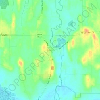
Name: Hebron topographic map, elevation, terrain.
Average elevation: 251 m
Minimum elevation: 237 m
Maximum elevation: 276 m
Other topographic maps
Click on a map to view its topography, its elevation and its terrain.
Kettle Moraine State Forest - South
United States > Wisconsin > Jefferson County
Average elevation: 274 m
Jefferson
United States > Wisconsin > Jefferson County
Jefferson's elevation is 797 ft (243 m) at the center of downtown.
Average elevation: 251 m
Lake Koshkonong
United States > Wisconsin > Jefferson County > Town of Koshkonong
Average elevation: 244 m
Aztalan State Park
United States > Wisconsin > Jefferson County > Town of Aztalan
Average elevation: 255 m