Geolocate

Emsbüren topographic map

Click on the map to display elevation.

About this map

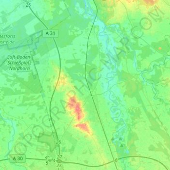
Name: Emsbüren topographic map, elevation, terrain.

Location: Emsbüren, Landkreis Emsland, Lower Saxony, 48488, Germany (52.33388 7.21252 52.48261 7.42664)

Average elevation: 32 m

Minimum elevation: 19 m

Maximum elevation: 71 m

Other topographic maps

Click on a map to view its topography, its elevation and its terrain.

Elbergen

Germany > Lower Saxony > Landkreis Emsland

Average elevation: 28 m

Mühlenmoor

Germany > Lower Saxony > Landkreis Emsland > Meppen > Helte

Average elevation: 17 m

Emen

Germany > Lower Saxony > Landkreis Emsland > Haren (Ems)

Average elevation: 13 m

Wörmer

Germany > Lower Saxony > Landkreis Emsland > Haren (Ems) > Wesuwe

Average elevation: 12 m

Gear up for your next adventure:

🧼Biodegradable Camp Soap - Environmentally friendly cleaning for gear and body
🦶Hiking Shoe Insoles - Added support for high arches and long days on feet
🥾Trail Hiking Boots - Supportive boots for rough trails
🧦Hiking Socks - Moisture-wicking and comfortable socks for long hikes
🎒Backpack Rain Cover - External shield to keep your entire pack dry

As an Amazon Associate, this site earns from qualifying purchases at no extra cost to you.