
Pog Lake topographic map
Click on the map to display elevation.
About this map
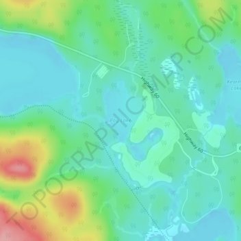
Name: Pog Lake topographic map, elevation, terrain.
Average elevation: 415 m
Minimum elevation: 384 m
Maximum elevation: 505 m
Other topographic maps
Click on a map to view its topography, its elevation and its terrain.
Carcajou Lake
Canada > Ontario > Nipissing District > Unorganized South Nipissing
Average elevation: 291 m
Smoke Lake
Canada > Ontario > Nipissing District > Unorganized South Nipissing
Average elevation: 439 m
Arrow Lake
Canada > Ontario > Nipissing District > Unorganized South Nipissing
Average elevation: 414 m
Madawaska Highlands
Canada > Ontario > Nipissing District > Unorganized South Nipissing
Average elevation: 371 m
Rose Lake
Canada > Ontario > Nipissing District > Unorganized South Nipissing
Average elevation: 459 m
William Lake
Canada > Ontario > Nipissing District > Unorganized South Nipissing
Average elevation: 421 m
Beau Lake
Canada > Ontario > Nipissing District > Unorganized South Nipissing
Average elevation: 416 m
Mizzy Lake
Canada > Ontario > Nipissing District > Unorganized South Nipissing
Average elevation: 459 m
Gilmour Island
Canada > Ontario > Nipissing District > Unorganized South Nipissing
Average elevation: 339 m
Coldspring Lake
Canada > Ontario > Nipissing District > Unorganized South Nipissing
Average elevation: 440 m
Windermere Lake
Canada > Ontario > Nipissing District > Unorganized South Nipissing
Average elevation: 355 m
Thistle Lake
Canada > Ontario > Nipissing District > Unorganized South Nipissing
Average elevation: 459 m