Geolocate

Gardner topographic map

Click on the map to display elevation.

About this map

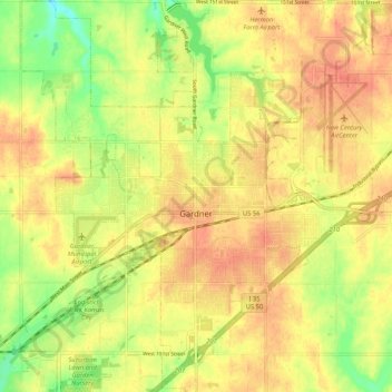
Name: Gardner topographic map, elevation, terrain.

Location: Gardner, Johnson County, Kansas, United States (38.77400 -94.97370 38.85484 -94.87142)

Average elevation: 317 m

Minimum elevation: 286 m

Maximum elevation: 336 m

Other topographic maps

Click on a map to view its topography, its elevation and its terrain.

Aubry

United States > Kansas > Johnson County

Average elevation: 325 m

Kill Creek Park

United States > Kansas > Johnson County > De Soto

Average elevation: 275 m

Olathe

United States > Kansas > Johnson County > Olathe

Average elevation: 302 m

Lenexa

United States > Kansas > Johnson County > Lenexa

Average elevation: 290 m

Gear up for your next adventure:

🥾Trail Running Boots - Durable shoes designed for trail running
🥾Mountaineering Boots - Supportive boots for climbing and high-altitude hiking
🌡️Emergency Mylar Blankets - Compact thermal protection for unexpected nights outdoors
🔭Compact Monocular - One-handed bird watching and trail spotting
🥾Trail Hiking Socks - Comfortable socks to prevent blisters and fatigue

As an Amazon Associate, this site earns from qualifying purchases at no extra cost to you.