Geolocate

Lenexa topographic map

Click on the map to display elevation.

About this map

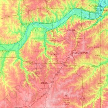
Name: Lenexa topographic map, elevation, terrain.

Location: Lenexa, Johnson County, Kansas, 66219, United States (38.80975 -94.94458 39.12975 -94.62458)

Average elevation: 290 m

Minimum elevation: 220 m

Maximum elevation: 341 m

Gear up for your next adventure:

🥾Mountain Hiking Shoes - Shoes with superior grip for mountainous terrain
🎒Hiking Daypack - Lightweight and durable backpacks for day trips and excursions
👟Leg Gaiters - Keep debris, mud, and snow out of your boots
🧊Portable Cooler - Keep food and drinks cold during outdoor adventures
🔦LED Headtorch - Bright and durable light for night activities

As an Amazon Associate, this site earns from qualifying purchases at no extra cost to you.