Geolocate

Province of Santa Cruz topographic map

Click on the map to display elevation.

Province of Santa Cruz

Santa Cruz Province's land area is 1,423 km2, 4.2% of the total of the Cajamarca Region. It is mostly mountainous in relief. It is located on the Western Mountain range of the Andes and is bounded by the mountains that descend to the coast and the deep rivers that carve the mountains. Its lowest elevation is in the Saña River, near the small village of Pan de Azucar, 265 meters above sea level, and highest in the Cerro Cimarrones, 3,600 meters above sea level, south of the town of Pulán.

Wikipedia (CC-BY-SA 3.0)

About this map

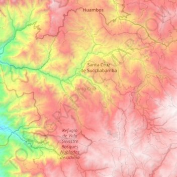
Name: Province of Santa Cruz topographic map, elevation, terrain.

Location: Province of Santa Cruz, Cajamarca, Peru (-6.87383 -79.25295 -6.50346 -78.71841)

Average elevation: 2,323 m

Minimum elevation: 277 m

Maximum elevation: 3,990 m

Other topographic maps

Click on a map to view its topography, its elevation and its terrain.

El Lirio

Peru > Cajamarca > Colasay

Average elevation: 1,585 m

Santa Cruz

Peru > Cajamarca

Average elevation: 511 m

Callancas

Peru > Cajamarca > San Pablo

Average elevation: 3,024 m

Regalado

Peru > Cajamarca > Tumbaden

Average elevation: 3,304 m

El Cardon

Peru > Cajamarca > Cutervo

Average elevation: 2,316 m

Alto Otuzco

Peru > Cajamarca > Los Baños del Inca > Otuzco

Average elevation: 2,827 m

Cruz De Chalpon

Peru > Cajamarca > San Ignacio

Average elevation: 1,488 m

Yube

Peru > Cajamarca > Callayuc

Average elevation: 1,589 m

Gear up for your next adventure:

🛏️Sleeping Bag - Warm and compact sleeping bags for outdoor camping
🧦Crew Hiking Socks - Comfortable socks for long-distance hikes
🧤Rechargeable Heated Gloves - Extreme warmth for Canadian winter expeditions
👖Convertible Hiking Pants - Zip-off legs to adapt to changing weather conditions
🥾Hiking Gaiters - Protect legs and shoes from mud, snow, and debris

As an Amazon Associate, this site earns from qualifying purchases at no extra cost to you.