Geolocate

Binaliw topographic map

Click on the map to display elevation.

About this map

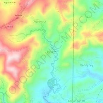
Name: Binaliw topographic map, elevation, terrain.

Location: Binaliw, Cebu City, Central Visayas, Philippines (10.40305 123.89486 10.44305 123.93486)

Average elevation: 213 m

Minimum elevation: 51 m

Maximum elevation: 438 m

Other topographic maps

Click on a map to view its topography, its elevation and its terrain.

Butuanon River

Philippines > Cebu City

Average elevation: 44 m

Fort San Pedro

Philippines > Cebu City

Average elevation: 3 m

San Roque

Philippines > Cebu City

Average elevation: 4 m

Hippodromo Park

Philippines > Cebu City

Average elevation: 13 m

Pari-an

Philippines > Cebu City

Average elevation: 8 m

TIEZA Pond

Philippines > Cebu City > Malubog

Average elevation: 471 m

Guadalupe River

Philippines > Cebu City

Average elevation: 220 m

Butuanon River

Philippines > Cebu City

Average elevation: 105 m

Kotkot River

Philippines > Cebu City

Average elevation: 316 m

SM Tower

Philippines > Cebu City

Average elevation: 3 m

Butuanon River

Philippines > Cebu City

Average elevation: 85 m

Butuanon River

Philippines > Cebu City

Average elevation: 41 m

CBP Central Park

Philippines > Cebu City

Average elevation: 19 m

Butuanon River

Philippines > Cebu City

Average elevation: 230 m

Sambag I

Philippines > Cebu City

Average elevation: 14 m

Mananga River

Philippines > Cebu City > Buot

Average elevation: 351 m

Buhisan Dam

Philippines > Cebu City > To-ong > Puti

Average elevation: 221 m

Gear up for your next adventure:

🥾Trail Hiking Boots - Supportive boots for rough trails
🛶Kayak Accessories - Essential gear for safe and fun kayaking adventures
🧰Emergency Multi-Tool - Compact multi-tool for outdoor survival
🚲MTB Frame Bag - Carry tools and maps directly on your bicycle frame
🧣Merino Neck Gaiter - Protects against wind, sun, and cold at high altitudes

As an Amazon Associate, this site earns from qualifying purchases at no extra cost to you.