Geolocate

Bat Cave topographic map

Click on the map to display elevation.

About this map

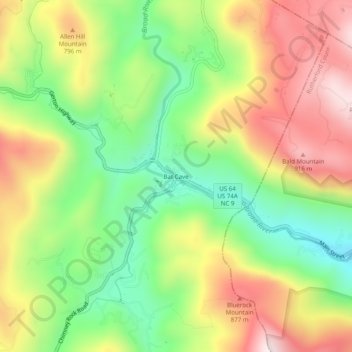
Name: Bat Cave topographic map, elevation, terrain.

Location: Bat Cave, Henderson County, North Carolina, 28710, United States (35.43151 -82.30706 35.47151 -82.26706)

Average elevation: 648 m

Minimum elevation: 364 m

Maximum elevation: 975 m

Other topographic maps

Click on a map to view its topography, its elevation and its terrain.

Etowah

United States > North Carolina > Henderson County

Average elevation: 652 m

Gear up for your next adventure:

🦯Trekking Poles - Reduced impact on joints for steep topographic climbs
🥽Outdoor Goggles - Protective eyewear for outdoor activities
🥾Hiking Shoes - Durable and comfortable shoes for trail hiking
🚑Survival Whistle - Signal for help across long distances in mountains
🔦UV Flashlight - Detect minerals or specific insects in the dark

As an Amazon Associate, this site earns from qualifying purchases at no extra cost to you.