
Hendersonville topographic map
Click on the map to display elevation.
About this map
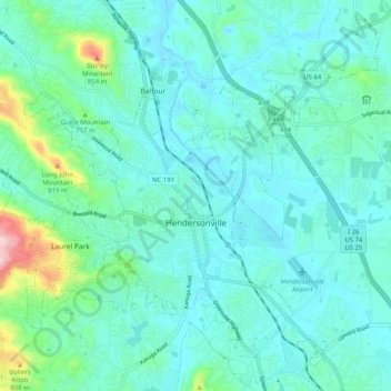
Name: Hendersonville topographic map, elevation, terrain.
Average elevation: 669 m
Minimum elevation: 624 m
Maximum elevation: 905 m
Other topographic maps
Click on a map to view its topography, its elevation and its terrain.
Patton Park
United States > North Carolina > Henderson County > Hendersonville
Average elevation: 655 m
Edneyville
United States > North Carolina > Henderson County
Edneyville is in northeastern Henderson County at an elevation of 2,246 feet (685 m) above sea level. The Eastern Continental Divide runs through the center of the CDP; the eastern side of the community drains via Reedypatch Creek to the Broad River, which flows through the Congaree and Santee River systems to…
Average elevation: 689 m
Chanteloupe Country Estates
United States > North Carolina > Henderson County > Flat Rock
Average elevation: 660 m
Flat Rock Forest
United States > North Carolina > Henderson County > Flat Rock > Flat Rock Forest
Average elevation: 681 m
Claremont
United States > North Carolina > Henderson County > Flat Rock > Claremont
Average elevation: 713 m
Mills River
United States > North Carolina > Henderson County > Mills River > Oak Hill Court
Average elevation: 644 m