Geolocate

Pamatawan topographic map

Click on the map to display elevation.

About this map

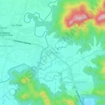
Name: Pamatawan topographic map, elevation, terrain.

Location: Pamatawan, Subic, Zambales, Central Luzon, 2208, Philippines (14.90439 120.20037 14.94439 120.24037)

Average elevation: 74 m

Minimum elevation: 14 m

Maximum elevation: 267 m

Other topographic maps

Click on a map to view its topography, its elevation and its terrain.

Mangan-vaca River

Philippines > Zambales > Subic > Ilwas

Average elevation: 33 m

Acid Lake

Philippines > Zambales > Subic

Average elevation: 390 m

Gear up for your next adventure:

🧤Thermal Hiking Gloves - Grip-enhanced gloves for cold-weather altitude trekking
🧢Sun Protection Cap - Breathable cap to protect from sun exposure
Camping Coffee Maker - Brew fresh coffee anywhere on the topographic map
🥾Trekking Boots - Durable boots for long-distance trekking
🥾Trail Running Shoes - Lightweight and durable shoes for trail running

As an Amazon Associate, this site earns from qualifying purchases at no extra cost to you.