Geolocate

Orrefors topographic map

Click on the map to display elevation.

About this map

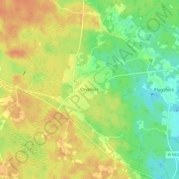
Name: Orrefors topographic map, elevation, terrain.

Location: Orrefors, Nybro kommun, Kalmar County, 380 40, Sweden (56.81948 15.72862 56.85948 15.76862)

Average elevation: 164 m

Minimum elevation: 144 m

Maximum elevation: 180 m

Other topographic maps

Click on a map to view its topography, its elevation and its terrain.

Nybro kommun

Sweden > Kalmar County

Average elevation: 109 m

Emmaboda kommun

Sweden > Kalmar County

Average elevation: 141 m

Hultsfreds kommun

Sweden > Kalmar County

Average elevation: 143 m

Emmaboda kommun

Sweden > Kalmar County

Average elevation: 141 m

Hansa City

Sweden > Kalmar County

Average elevation: 7 m

Högsby kommun

Sweden > Kalmar County

Average elevation: 97 m

Store Hindsjön

Sweden > Kalmar County

Average elevation: 118 m

Mönsterås kommun

Sweden > Kalmar County

Average elevation: 26 m

Alen

Sweden > Kalmar County

Average elevation: 142 m

Oskarshamns kommun

Sweden > Kalmar County

Average elevation: 63 m

Kalmar kommun

Sweden > Kalmar County

Average elevation: 28 m

Gear up for your next adventure:

🧥Softshell Hiking Jacket - The perfect balance of wind protection and breathability
🔋Emergency Crank Radio - Weather alerts and power without needing batteries
🧣Evaporative Cooling Towel - Beat the heat during intense summer climbs
🚲Bike Repair Kit - Essential tools for on-trail mechanical issues
🐕Hiking Dog Pack - Let your canine companion carry their own water and food

As an Amazon Associate, this site earns from qualifying purchases at no extra cost to you.